Chapter 13
Area
All lands shown as “High Risk”, “Moderate Risk” or “Wildland” on Schedule S are designated as a Development Permit Area for the protection of development from wildfire.
Designation
Pursuant to section 488(1)(b) of the Local Government Act, these lands are hereby designated a development permit area for protection of development from hazardous conditions; specifically wildfire. These lands are also designated under section 484 of the Local Government Act as areas in which the municipality may require applicants to provide information on the risks of development, specifically the risk of development being damaged by or spreading wildfire.
Justification
Wildfire can result in significant economic, social and environmental losses. The municipality is 24,375 hectares in size and more than 65 per cent of this area is forested. While the probability of wildfire in Whistler is lower compared to communities in B.C.’s interior, the consequences of wildfire in Whistler could be significant given real estate values, access and evacuation constraints, population size, topography, and impacts on tourism. Whistler is expected to experience hotter and drier summers as a result of climate change, which will exacerbate both the risks and consequences of wildfire. Most of Whistler’s developed and planned urban areas are in or near the wildfire urban interface. Forested areas surrounding Whistler are also at risk because these areas are popular for outdoor recreation and resource extraction uses. Because wildfire can be triggered from structure fires and human activity, the probability of a structure fire in Whistler spreading to the surrounding forest is equal to, or greater than, the probability of a wildfire spreading from the forest into the community. Applying wildfire development permit guidelines to new development will mitigate the likelihood and consequences of all wildfire scenarios. Schedule S identifies three distinct areas where these guidelines will be applied to reduce the risk and impacts of wildfire:
- Moderate Risk Areas: These areas are typically developed areas that are not adjacent to or surrounded by forests. In these areas, key building and landscape features in the areas immediately surrounding principal buildings may be required.
- High Risk Areas: These areas are typically developed areas or developable land near or adjacent to forest. In these areas, a number of building features, landscaping, site clearing and tree thinning may be required.
- Wildland Areas: These areas are predominantly undeveloped forested areas. Urban development is not typically planned or located in these areas. However, when new development is proposed in these areas, FireSmart® Assessments may be required. This requirement also extends to resource extraction and outdoor recreation uses, but only when occupied structures (e.g., cooking/warming huts or cabins) are proposed.
Exemptions
Pursuant to section 488(4) of the Local Government Act a development permit is not required in respect of the following:
- (a) development for which a building permit is not required under the municipality’s Building Bylaw, except for a complete roof replacement;
- (b) renovations to existing buildings, other than additions to buildings and complete roof replacement;
- (c) complete roof replacement with materials other than untreated wood shakes;
- (d) any development in the area shown on Schedule S as “Moderate Risk”, provided that the proposed development will not include:
- (i) a new roof or a complete roof replacement using untreated wood shakes as a roofing material;
- (ii) new coniferous vegetation within 3 metres of a principal building, measured from the outermost part of the building to the trunk of the tree, shrub or hedge as applicable;
- (e) auxiliary buildings except for detached auxiliary residential dwelling units;
- (f) auxiliary residential dwelling units within an existing dwelling unit, provided no addition to the existing dwelling unit is proposed;
- (g) development on lands subject to a covenant that is registered in favour of the municipality under section 219 of the Land Title Act for the protection of development from wildfire;
- (h) subdivision;
- (i) any development comprised entirely of non-flammable materials such as metal, stone or concrete;
- (j) public works or infrastructure, including roads, bridges, sewer and water infrastructure, electrical distribution systems and ski lifts;
- (k) works undertaken in a park; or
- (l) vegetation or tree removal.
Guidelines
The following guidelines apply within the Wildfire Protection DPA:
ALL AREAS
The following guidelines apply to all areas shown on Schedule S:
- (a) Where a distance is specified by these guidelines for the purpose of establishing an area that should be cleared or remain free of vegetation, the distance should be measured from the outermost part of the building to:
- (i) the distance specified in the guideline;
- (ii) the property line, unless permission has been granted by the adjacent property owner; or
- (iii) the boundary of an environmentally sensitive area unless clearing is carried out in accordance with the recommendations of a QEP and approved in writing by the municipality’s Manager of Environmental Stewardship
whichever is closer.
- (b) Where the municipality receives a FireSmart® Assessment in respect of a property which is the subject of an application for a development permit under this section, the municipality may choose to apply, as permit conditions, the recommendations of the report instead of, or in addition to, the guidelines in this section.
- (c) Where these guidelines warrant tree removal preference should be given to:
- (i) retaining the largest and healthiest trees;
- (ii) removing coniferous vegetation located closest to principal buildings; and
- (iii) retaining deciduous trees and vegetation.
MODERATE RISK AREAS
In areas shown as “Moderate Risk”, on Schedule S, the following guidelines apply:
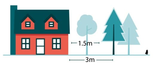
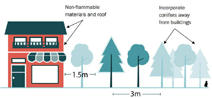
- (a) All areas within 1.5 metres of principal buildings should be free of coniferous vegetation. This can be achieved by:
- (i) planting/removing conifers so as to create a trunk to building spacing of at least 3 metres; or
- (ii) limbing mature trees, selecting species with narrow canopies or applying similar landscaping techniques to obtain a 1.5 metre vertical and horizontal separation between tree canopies and principal buildings.
- (b) Dead branches and twigs should be cleared within 20 metres of principal buildings. Standing dead trees with a caliper of 17 centimetres or more should be topped at 3 metres and cleared of all branches. Where dead branches are attached to logs greater than 17 centimeters wide or to trees, they should be trimmed to the trunk of the tree or log and in the case of trees, to a height of 2 metres.
- (c) Planting native deciduous trees and shrubs is encouraged especially in cases where coniferous vegetation has been removed.
- (d) Roof structures should be comprised of fire-resistant roofing. Metal, clay tile, asphalt shingle and similar roofing materials should be used wherever possible. Where wood shakes are used, only treated wood shakes are acceptable.
- (e) Gutters should be made of metal.
- (f) Cladding should be separated from the ground with a minimum of 15 centimeters of non-combustible ground to siding clearance.
- (g) Notwithstanding guideline (a), in areas shown as “Moderate Risk” within Whistler Village, as indicated on Schedule S, the following guidelines will also apply:
- (i) Individual coniferous trees may be located within 1.5 metres of a building, provided:
- 1. no other conifers are within 3 metres (measured from trunk to trunk) of the conifer;
- 2. exterior portions of the building fronting the tree’s existing and eventual canopy are clad in non-flammable materials such as stone, metal, concrete, masonry or fiber-cement; and
- 3. building roofing is comprised of metal, clay tile, fibre-cement or similar material; wood shakes of any kind are not acceptable.
- (ii) To preserve coniferous landscaping in Whistler Village, as indicated on Schedule S, landscaped areas, especially landscaped areas beyond 1.5 metres from a building, should incorporate coniferous trees and vegetation so as to achieve an overall mix of coniferous and deciduous trees. Clusters of mature coniferous trees should be spiral pruned.
- (i) Individual coniferous trees may be located within 1.5 metres of a building, provided:
HIGH RISK AREAS
In areas shown as “High Risk” on Schedule S, the following guidelines apply:
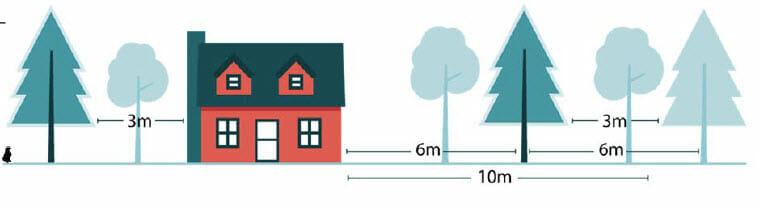
- (a) New and existing coniferous vegetation within 10 metres and where practical 20 metres of principal buildings should maintain a typical spacing between tree canopies and between tree canopies and principal buildings of at least 3 metres. This can be achieved by:
- (i) planting/removing conifers to achieve a trunk to trunk or trunk to building spacing of 6 metres or more; or
- (ii) limbing mature trees, selecting species with narrow canopies or applying similar landscaping techniques to obtain a minimum 3 metre vertical and horizontal separation between tree canopies and between tree canopies and principal buildings.
- (b) Dead branches and twigs should be cleared within 20 metres of principal buildings. Standing dead trees with a caliper of 17 centimetres or more should be topped at 3 metres and cleared of all branches. Where dead branches are attached to logs greater than 17 centimetres wide or trees they should be trimmed to the trunk of the tree or log and in the case of trees, to a height of 2 metres.
- (c) Planting native deciduous trees and shrubs is encouraged especially in cases where coniferous vegetation has been removed.
- (d) Notwithstanding guideline (a) in areas shown as “High Risk” within Whistler Village, as indicated on Schedule S, the following guidelines will also apply:
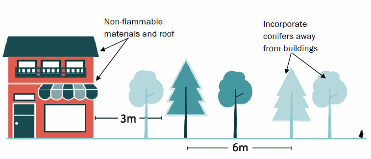
- (i) Individual coniferous trees may be located within 3 metres of a building, provided:
- 1. no other conifers are within 6 metres (measured from trunk to trunk) of the conifer;
- 2. exterior portions of the building fronting the tree’s existing and eventual canopy are clad in non-flammable materials such as stone, metal, concrete, masonry or fiber-cement; and
- 3. building roofing is comprised of metal, clay tile, fibre-cement, asphalt shingle or similar material; wood shakes of any kind are not acceptable.
- (ii) To preserve coniferous landscaping in Whistler Village, as indicated on Schedule S, landscaped areas, especially landscaped areas beyond 3 metres from a building, should incorporate coniferous trees and vegetation so as to achieve an overall mix of coniferous to deciduous trees. Clusters of mature coniferous trees should be spiral pruned.
- (i) Individual coniferous trees may be located within 3 metres of a building, provided:
- (e) The use of bark mulch and similar organic ground cover in landscaped areas within 10 metres of buildings is discouraged.
- (f) Exterior building surfaces, including deck surfacing, roofing and cladding, that is situated under, or within 6 metres of, coniferous vegetation should be non-flammable materials such as stone, metal, concrete, masonry or fiber-cement.
- (g) Fire-resistant or non-flammable cladding that is consistent with mountain character (e.g., fiber-cement siding, stone, logs or heavy timbers) is encouraged. Stucco and vinyl siding are discouraged.
- (h) Windows and doors should utilize double-paned or triple-paned glass; tempered glass is ideal, and single pane glass is discouraged.
- (i) Eaves should be closed and vents screened with 3 millimetre wire mesh.
- (j) The undersides of balconies, decks or open foundations should be sheathed with fire-resistant materials.
- (k) Auxiliary buildings and fuel tanks should be located as far away from principal buildings as possible. A distance of 15 metres or more is ideal. Where a distance of 15 metres or more is impractical, guidelines in this section that apply to principal buildings should be applied to accessory buildings.
- (l) Chimneys for wood burning fireplaces should have spark arrestors.
- (m) Gutters should be made of metal.
- (n) Cladding should be free of gaps and holes and separated from the ground with a minimum of 15 centimeters of non-combustible ground to siding clearance.
WILDLAND AREAS
In areas shown as “Wildland” on Schedule S, the following guidelines apply:
- (a) For new development a FireSmart® Assessment indicating that the proposed development has a hazard score of “Low” or “Moderate” is required and a development permit may require that development be carried out in accordance with any recommendations of the report including:
- (i) recommendations related to areas of the land that should be cleared or remain clear of vegetation;
- (ii) recommendations related to landscaping, including locations of plantings, surface treatments, plant and tree species, thinning and maintenance;
- (iii) recommendations for particular building materials and features; and
- (iv) recommendations pertaining to the location of structures in relation to other structures, or topographical or natural features that are wildfire hazards.