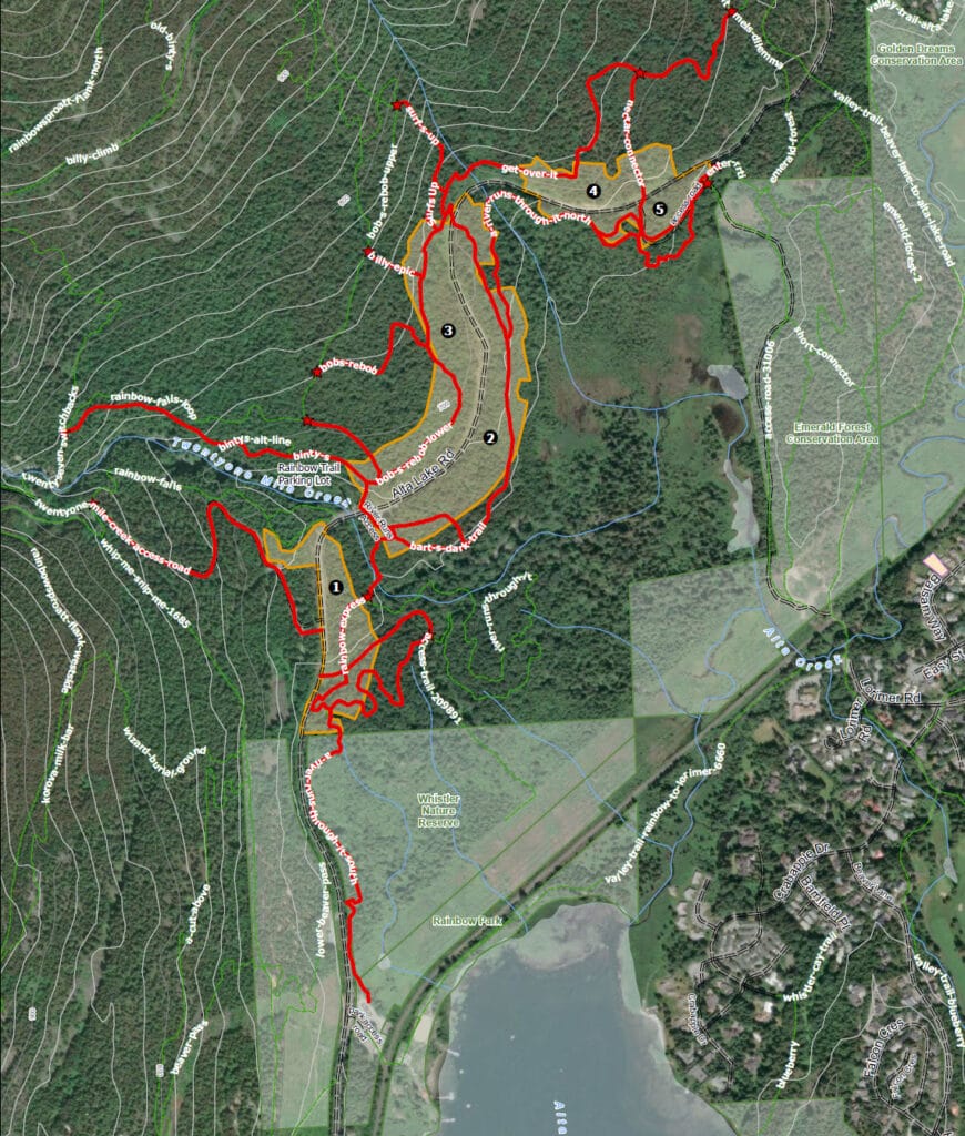
Wildfire fuel management is underway on the north end of Alta Lake Road in map area unit 1. Some trails in the area will have temporary closures: please respect all signs and staff for safety reasons.

Wildfire fuel management in Whistler
The Resort Municipality of Whistler has been conducting wildfire vegetation management (also known as fuel thinning) projects on Crown and municipal lands since 2004 to reduce the risk of wildfire to our community. The primary goal is to reduce forest fuel loads within the wildland-urban interface to reduce the ability of fire to spread from the forest into the community and vice versa, and to make wildfires easier to fight. Fuel thinning will be discontinued when the fire hazard goes to extreme and will resume when the fire hazard is lower.
Sometimes projects need to burn some of the wood debris. We will alert the public through social media. There is no need to report smoke from fuel thinning projects.
Current projects
Alta Lake Road (north)
The Cheakamus Community Forest (CCF) and RMOW are partnering on this project along the north end of Alta Lake Road, from 21 Mile Creek towards Alpine Meadows. Operations are set to begin in late February/early March and continue through to autumn 2026. The early seasonal start to the work will help minimize impacts to the ground and to users of the many multi use trails in the work area. Crews will work through the treatment units sequentially, along this general timeline:
- Unit 1 – late February to early April. River Runs Through It/Rainbow Express trails, above cemetery, Rainbow Falls and Between the Creeks (lower) will have intermittent closures.
- Unit 2 – Mid/late March through June. Bart’s Dark Trail will be closed for duration. RRTI North on to Bart’s Dark Trail will be diverted to Alta Lake Road. RRTI access trail will have 4-5 days closure during initial treatment.
- Unit 3 – Potential summer start (wildfire risk and crew availability permitting) for 2-3 weeks. Affects Bob’s Rebob, Billy Epic with intermittent closures.
- Unit 4 – Late March through June. Get Over It and Nectar Connector will have 2-3 days of full closures during falling/yarding operations, then intermittent closures when yarding trees near trails.
- Unit 5 – Summer or fall start for 2-3 weeks. Affects the gravel pit access road down from Alta Lake Road to the pit (not Emerald Forest section); intermittent closures.

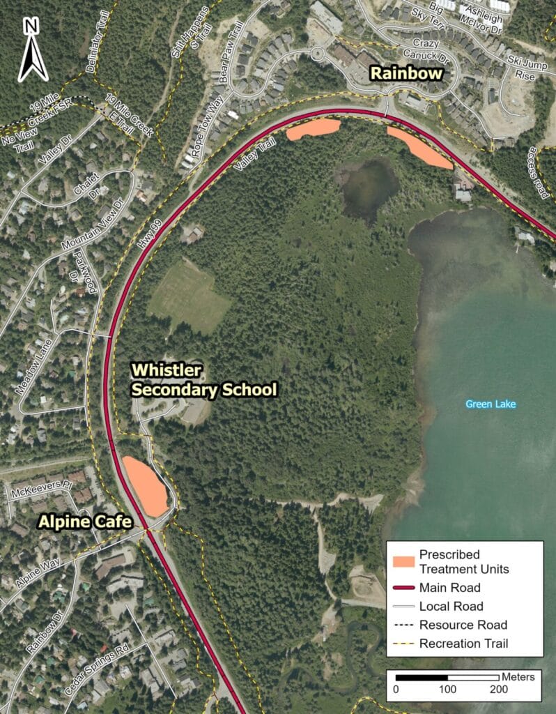
Highway 99 TU-1B (Alpine Meadows/Rainbow subdivisions)
This project is aimed at reducing wildfire risk along Highway 99 — Whistler’s key transportation corridor and primary evacuation route.
Starting in early spring 2026, we will be managing vegetation along Highway 99 in treatment area TU-1B, located near the Alpine Meadows and Rainbow subdivisions.
For the northeastern-most area by the Rainbow subdivision entrance on Crazy Canuck Drive, there will be flaggers on the Valley Trail to conduct short intermittent closures as needed. There will also be temporary Valley Trail detours between the Rainbow subdivision entrance and Alpine Way to facilitate fuel thinning operations.
Work will begin on April 7, 2026 and is expected to continue for three to four weeks, weather permitting.
16 Mile Road
The Cheakamus Community Forest (CCF) and RMOW are partnering on this wildfire management project at 16 Mile Valley, above The Adventure Group (TAG) base area. Operations will begin in autumn 2026 and continue as long as weather/snow conditions allow, resuming in spring 2027. The CCF and RMOW are also in close contact with TAG to understand their operations logistics and minimize impacts to their business
More details to follow.
Completed projects
We’ve completed fuel management work in the following areas:
- Highway 99: treatment areas 1A and 2A near Emerald Estates
- Stonebridge, 2025
- Emerald west and Brio extension, 2025
- Whistler Cemetery, 2025
- Emerald west, 2024
- Brio, 2024
- Brio extension, 2024
- Panorama Ridge Brio, 2023
- Kadenwood Gondola, 2023
- Riverside Cheakamus Crossing, 2023
- Rainbow 1 neighbourhood project, 2023
- Cheakamus Lake Road Fuel Treatment, 2021
- Cheakamus Lake Road, 2020
- Spruce Grove/Lost Lake Park, 2019-20
- Nesters Hill, 2020
- High school site fuel thinning
- Taluswood wildfire fuel thinning, 2021-22
- Rainbow 2, 2022
Process and goals
Vegetation management focuses on leaving mature and deciduous trees, while removing ground brush and debris, pruning lower branches, and removing tight, unmanaged second growth trees. This is accomplished by:
- Reducing the number of trees in the stand to open the upper tree canopy and reduce ability of fire to move from tree to tree;
- Focusing on removal of small diameter trees and retaining fire-resistant species such as old growth, Douglas-fir and deciduous trees;
- Reduce fine woody surface debris, while retaining larger coarse woody debris for habitat and soil productivity;
- Pruning trees to reduce ladder fuels between the ground and the forest crown; and
- Removing dangerous trees to protect workers, while maintaining high value wildlife trees where possible.
In addition to reducing forest fuel loads, secondary objectives are to protect critical infrastructure and facilities in Whistler, restore open forest conditions and demonstrate the principles and practices of the FireSmart program.
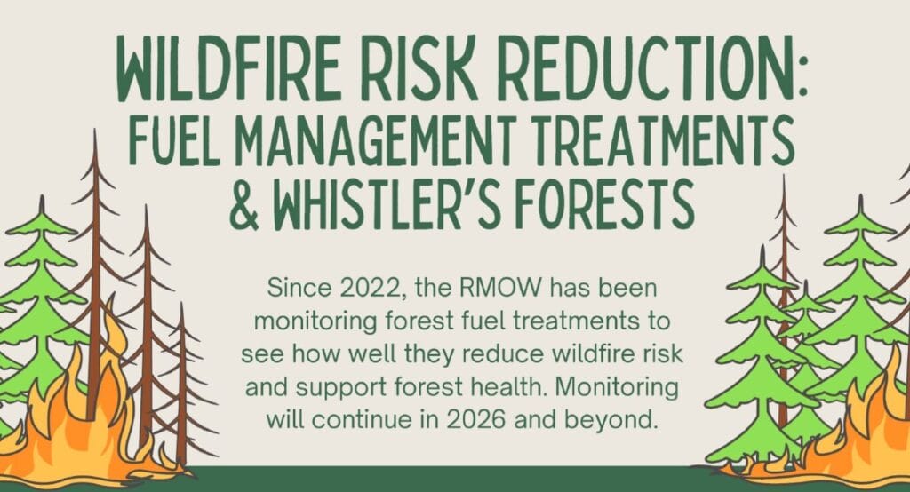
Wildfire fuel treatments – monitoring program
Since 2022, the RMOW has been monitoring our forest fuel treatments to see how they impact wildfire risk and forest health. Results over the past 4 years show that fuel treatments significantly reduce extreme wildfire behaviour and maintain healthy, more fire-resilient forests.
Click here (PDF) for more information on Whistler’s fuel treatment monitoring program.
Community Wildfire Resiliency Plan – update now underway
Our Community Wildfire Resiliency Plan (PDF) (CWRP) is Whistler’s overall strategic plan for reducing wildfire risk. In February 2026, we began the process of updating the 2022 CWRP, with completion planned for early 2027. The new CWRP will be implemented over the next 5-10 years.
The key strategies of the 2022 CWRP include:
- Education
- Community planning, legislation & development considerations
- Interagency cooperation
- Training and cross-training
- Emergency planning and preparedness
- Vegetation management
Wildfires know no boundaries with respect to jurisdiction and land ownership. As such, collaboration is key when it comes to mitigating the risks of wildfires. The CWRP update will engage key local and regional partners to ensure a coordinated and collaborative approach. Bringing partners together builds shared ownership and helps ensure that the CWRP reflects local knowledge, works across relevant partners’ regulatory and operational jurisdiction, and improves wildfire preparedness across the whole community.
Vegetation management is a key component of Whistler’s CWRP. The updated CWRP will integrate wildfire fuel treatment history and landscape-level wildfire threat modeling to ensure that future actions are strategic, scientifically informed and targeted for the greatest impact in safeguarding the community.
Stay tuned for more information on this project over the summer.
Related files
Community Wildfire Resiliency Plan (PDF)
Wildfire Risk Reduction: Fuel Management Treatments & Whistler’s Forests (PDF)