The RMOW is leading the development of a non-motorized Recreation Trails Strategy (RTS) that will guide direction related to trail and trail-related amenity development, improvement, access, funding and management.
Overview
In Whistler, trails exist on Resort Municipality of Whistler (RMOW) property, crown land, private property, and in some cases leased land. Decisions related to Whistler’s trail networks can be complex given the multiple jurisdictions and stakeholders involved.
The purpose of the Recreation Trails Strategy is to guide how decisions are made related to trail management and development in Whistler.
The Recreation Trails Strategy will not specify the number, location or types of trails, which will be the focus for a future and more detailed non-motorized Trails Master Plan.
Elements being considered through the development of the Recreation Trails Strategy include:
- Trail access and staging areas
- Environmentally responsible trail development
- Trail inventory
- Trail approval process
- Unsanctioned trails
- Communications
- Commercial and event use
- Trail funding
Given the urgent nature of some of the elements above, recent initiatives have been undertaken, including management and monitoring initiatives related to grizzly bears, alpine areas and e-bikes. Ongoing trails implementation and engagement will also continue in parallel, and in coordination to this work. A more complete list of recent initiatives is included in the Background section below.
Objectives
- Achieve shared high-level direction related to:
- Non-motorized trail and trail-related amenity development, improvements, access, funding and management, including approaches, practices and responsibilities
- Potential areas for future trail connectedness, development and improvement
- Emerging trail user types and needs
- Non-motorized trail-related challenges that have emerged in recent years
- Establish the groundwork for a future and more detailed Trails Master Plan
- Enhance community understanding of the breadth and complexity of trail management, and the associated financial implications
- Identify reliable and consistent funding sources for annual trail maintenance
- Develop a clear, easy to use Recreation Trails Strategy document that articulates shared trail-related direction and integrates all key trail-related topics together in one place
Project phases and timelines
Project Planning (complete): The project planning phase included defining project parameters, an online survey, and the development of a request for proposal (RFP) to seek consultants to assist with the Recreation Trails Strategy. Results from the March 2021 community survey were used to gather input from community members about trail-related challenges, goals and current initiatives to help inform project planning. Following a public Request for Proposals call, Cascade Environmental Resource Group Ltd. and the Whistler Centre for Sustainability were retained by the municipality in May 2022.
Strategy Development (significantly complete): The strategy development phase and deliverables was determined through the project planning phase and were finalized with assistance from the project consultants. It includes trail-related amenities such as trailhead parking and washrooms, trail signage, lookouts, and more. This is currently in draft form and is under review.
Community engagement
Community members, trail special interest groups, land managers and partners have been engaged throughout the project. This included:
- Trails Planning Working Group
- Forest and Wildland Advisory Committee
- Recreation Leisure Advisory Committee
- Whistler Bear Advisory Committee
- WORCA
- AWARE
- Alpine Club of Canada (Whistler Section)
- Trials99 (observed trails riding)
- Squamish Nation
- Lil’wat Nation
- Cheakamus Community Forest
- Recreation Sites and Trails BC
- Other land managers
Project scope
Trails within the scope of the RTS include off-road trails on municipal, Crown and private land, including those that are formally established and those that are not. It also includes trail-related amenities such as trailhead parking and washrooms, trail signage, lookouts, etc. The Valley Trail network and resource roads (including forest service and resource or infrastructure access roads) are generally outside of the project scope. However, where they provide access to or have an impact on recreational off-road trails, they have been considered in the project.
While non-motorized, non-winter (i.e. spring, summer, fall) recreational trail use will be the focus of the Recreation Trails Strategy there is one motorized exception: observed trials motorcycles. Observed trials motorcycle use are included as it predates mountain biking in Whistler, continues to this day, and many of today’s mountain bike trails originated as trials motorcycle trails.
Dirt motorcycles (also known as dirt bikes), snowmobiles and snow bikes are excluded from this project as they are prohibited from using the recreational non-motorized trails targeted in this project. Snowmobile use on Mount Sproatt and Rainbow Mountain are also excluded from this project. These uses are currently managed by the local snowmobile clubs and Recreation Sites and Trails BC, with direct input from the RMOW.
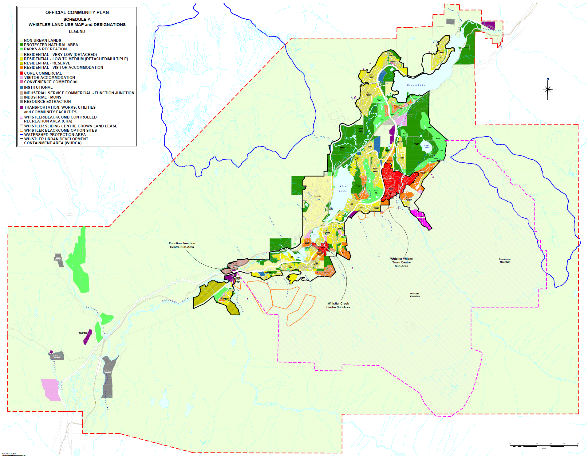
The geographic scope of the project covers the area within Whistler’s municipal boundary (see red dotted line on the map below). Particular emphasis has been placed upon the interface between the Whistler Urban Development Containment Area boundary (black solid line surrounding the Whistler’s developed area) and adjacent and tenured lands, as well as assets of municipal interest or investment outside of the municipal boundary such as the alpine trail networks on Mount Sproatt and Rainbow Mountain. The Whistler Interpretive Forest is included. Whistler Blackcomb’s Controlled Recreation Area (pink dotted line), Garibaldi Provincial Park (BC Parks) and Whistler Olympic Park are excluded from the scope, but engagement has occurred with these organizations for compatibility reasons.
Background
Collectively, Whistler’s non-motorized recreational trails:
- provide a renowned recreational experience for thousands of people annually
- are a significant driver of local and provincial economic activity in the summer
- contribute immensely to the physical, mental and spiritual health and well-being of Whistler residents and visitors
- are critical to the sense of place and way of life in Whistler.
The natural environment where trails are located underpin these health, social and economic benefits.
In the absence of a formal trail master plan, Whistler’s trail network has grown organically over the decades, initially with hiking and motorized trials motorcycle riding, and later mountain biking. The network exists in a range of environments, including valley bottom areas, forests of second and old growth trees, logged areas, and alpine zones.
The trail network exists across a variety of jurisdictional responsibilities, and while some trails possess formal standing, many others do not. Those that are formally recognized are managed by a variety of organizations overseeing a complex, yet incomplete, ownership and responsibility matrix.
Whistler trail users include hikers, mountain bikers, trail runners, dogs, events, commercial users, and more. Over the last five years recreational trail use has increased significantly in almost every jurisdiction in the province, and Whistler is no exception. The explosion in trail use is fueled by population growth, transportation and access improvements, e-bike technology and, more recently, the COVID-19 pandemic.
Surging use brings new and exacerbated challenges, including those related to trailhead parking and amenities, trail overcrowding, trail maintenance, natural areas protection, wildlife conflicts and more.
There have been many trail-related planning, development, maintenance and management initiatives over the years by a collection of partners and players, including trail builders, WORCA, Recreation Sites and Trails BC, Alpine Club of Canada (Whistler section), and Trials 99. Recent and upcoming key initiatives include:
- Improvements to further protect Rainbow Lake and 21 Mile Creek water supply area (RMOW)
- For the alpine trails located upon Mount Sproatt and Rainbow Mountain, the Alpine Ranger Program, the Grizzly Bear-Human Conflict Mitigation Strategy, the Grizzly Bear Response Plan, and an annual monitoring program (RMOW)
- Draft e-bike policy (RMOW)
- Parking signage improvements in neighbourhood areas (RMOW)
- Facility improvements at select trailheads (RMOW)
- Provision of trail access from Emerald Estates to One Duck Lake trail network (RMOW)
- New trail development, including Chipmunk Rebellion, Tunnel Vision Connector, FarOut/Flashback (WORCA)
- Development of a coordinated approach regarding unauthorized trails and commercial use of authorized trails located upon Crown lands (RSTBC)
- Fitzsimmons Creek Trail and bridge (Singing Pass) planning and approval (RSTBC)
- Development of an RMOW Non Exclusive Use Permit system (pilot program) for organized groups seeking to use municipal trails
- Development of a WORCA Special Events Trail Policy providing a framework for creating positive working relationships with event organizers while sustainability managing WORCA-maintained trails for all stakeholders over the long term
Guiding documents
The documents below will help guide the development of the Recreation Trails Strategy.
Overarching plans
- Vision and Official Community Plan (RMOW 2018)
- Climate Action “Big Moves” Strategy (RMOW 2020)
- Sea to Sky Land and Resource Management Plan (FLNRO 2008)
Strategic plans
- Sea to Sky LRMP Coordinated Access Management Plan (FLNRO 2009)
- Road Based Access Management Plan (Cheakamus Community Forest 2018)
- Recreation and Leisure Master Plan (RMOW 2015)
- Strategic Plan 2021-2024 (WORCA 2020)
Supplemental plans
- Whistler Trail Standards – Environmental and Technical Features (RMOW 2003)
- Report on Whistler Area Hiking Trails (FWAC Hiking Trail Task Force 2012)
- Mountain Bike Trails Master Plan and Engagement (WORCA 2017)
- Human-Grizzly Bear Conflict Mitigation Strategy (RMOW 2019)
- Draft E-Mobility Policy (RMOW 2019)
- Sea to Sky Corridor Recreation Trail Strategy (RSTBC 2008)
- Trails Strategy for BC (RSTBC 2013) and subsequent Trails Strategy Review in progress (RSTBC 2020)
- Authorizing Recreational Mountain Bike Trails in Provincial Crown Land – Operational Policy (RSTBC 2013)
- Economic Impact Study Whistler Mountain Biking (RMOW, TW, WB 2016)
Emerging municipal plans
- Active Transportation Plan
- Priority Habitat Management Strategy
- Wildfire Resiliency Plan
Funding
The Recreation Trails Strategy project is 100 per cent funded from the Province of British Columbia through its Resort Municipality Initiative (RMI) program.